Hello,
I was wondering how well the Kompakt is suitable for mountain tours, so I have the following questions:
Can I display contour lines and terrain on the map display?
Or how well is open terrain and mountains displayed?
Hello,
I was wondering how well the Kompakt is suitable for mountain tours, so I have the following questions:
Can I display contour lines and terrain on the map display?
Or how well is open terrain and mountains displayed?
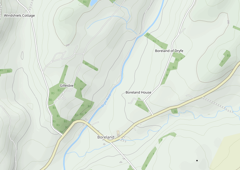
I’m not sure what you mean by ‘contour lines’
But there are differences in terms how terrain is displayed.
OSM has contour line data used to show terrain hight detail (see attached), but this isn’t often used by map apps by default, its usually available in alternative ‘biking’ or ‘walking’ map overlays, but the data is technically all there, its just not displayed.
counter lines would probably make whats already quite a noisy looking map on eink paper even more noisy.
id actually like to see some data removed from the screen shots you showed (simplify whats rendered to just important objects, poi’s and terrain) but maybe thats another topic.
Contour lines are lines that create a 3d effect in outdoor maps and show the altitude easily readable. It also provides information about how steep the terrain is.
But as @eden has already said, it may not be optimal in eink screens
That’s what I meant by contour lines:
Oh, I get it now. Thanks for the clarification. Yeah, it’s really hard to show this on E Ink.
This is what a map with contour lines looks like on my eink tablet. It actually looks good.
If the Kompakt doesn’t have it, it would be really cool if they could add the function. maybe with a route planning function.
Just as an idea ![]()
from your photo it looks like they might be using the default layers/tileset? Lele’s request could be something that could be added if there’s an option to select different tile sets in the maps app? or if the deveopers look to change what tileset is used to use one that suits eink in better ways
Topographic map == contour lines. I don’t think the shaded relief maps would work well on the Kompakt. Your image on your eink tablet looks awesome though (topo map).
Topo maps would probably work fine on a Kompakt when zoomed in far enough. We would not get a good view (overview) as displayed in your image w/ the Kompakt.
I’ll second, third or fourth the idea of topographic maps availability on the Kompakt.
It’s third-party open source kind of data (base maps / layers), so it could be done, just not sure of the priority for Mudita vs. other threads I’ve read here?
I have now downloaded Outdooractive and find that it functions well. During mountain tours, the display is also significantly clearer than conventional ones, as the light intensity is very high.
Cool, thanks lele. On your last pic, I can even see what looks to be an avalanche slope with run-out zone fingers through the trees.
Initially (for a few months+ perhaps), I’m not planning on sideloading any apps on my Kompakt, but I’ll bookmark your discovery. I’ll also research Outdooractive and their privacy/tracking policy and as I always do: Follow-the-money. Years ago we used a tool from charlesproxy to debug and view sockets on ios devices. It was quite enlightening. I trust phones for privacy/tracking about as much as I’d trust posting my banking account details on the internet and expecting that my account balance stays above 0.00 ![]()